


ALTO GARDA
Info Departure: Campione (m. 74 s.l.)
Arrival: Campione (m. 74 s.l.)
Total difference in height (round trip): 680 m.
Time: 3 hours
Difficulty: ( E ) Excursionist. Itineraries on trails or tracks, usually marked and sometimes long, with exposed but well-protected sections. These routes require some experience and training.
Period: all year
Map: Kompass n. 071, 101 e 690
Access: from State road S.S. 45 bis for Campione, between Limone and Gargnano; parking.
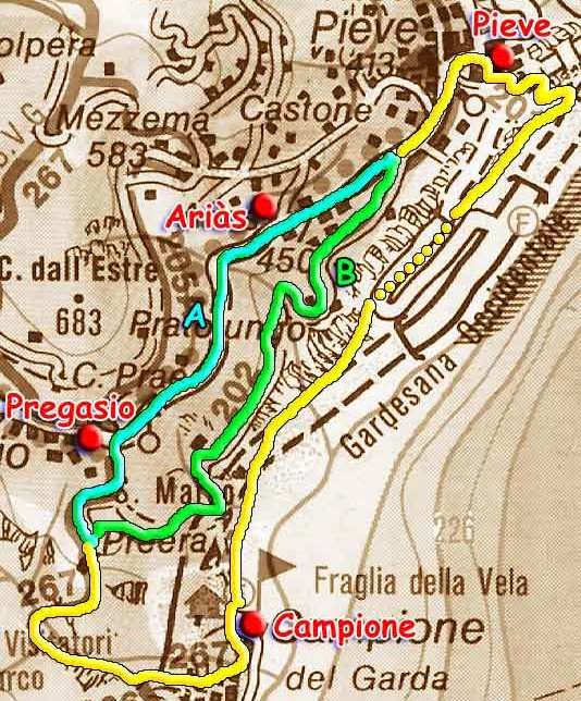
Starting out from Piazza F. Arrighini, take Via G. Pascoli. Beyond the soccer field, take the abandoned stretch of the Gardesana road. Passing the two tunnels, keep left along the road that passes below the waterfall of the Lesine river and gently ascends to the Province road nr. 38 (20 min). The road ascends for 200 meters, then you arrive at a tunnel entrance. Bear right and take the old trail, where you’ll find the attractive sign “Benvenuti a Tremosine” (Welcome to Tremosine). Proceed until you encounter trail nr. 201 (10 min.) that connects the port (visible below) with the homes of the regional capital up above. Once you pass the rocks of a rockslide, you’ll see that the road turns into an unpaved road. You’ll pass the vertical shelf running along a rocky crag, then you’ll meet up with a small cavern with a statue of the Madonna. A short distance after, you’ll have reached the summit (413 m, 40 min.).
Once you’re on Viale Europa, you’ll proceed to the point of the former city hall and the schools, where you have two options:
a) – take the Provincial “Arias” road and when you reach Pregasio (478 m), near the San Marco church, take Via Lo on the left, which coincides with trail 267 of the Bassa Via del Garda;
b) – take Via Vagne, following trail nr. 202 on the side of the church oratory, and descend until you reach the gate of a private home that blocks the road, then take the trail that borders the fence, pass through the chestnut grove and exit on Via Lo.
Take the easily accessible mule trail where the itinerary meets up once again, and proceed to an isolated hay barn surrounded by olive trees (1 hour). A panoramic trail that in some sections was literally dug out of the rock leads to the San Michele ravine, which you cross by way of a metal bridge. Bearing left, follow trail nr. 267 amidst the nets. You’ll go through the cramped tunnel (bring a flashlight!), and reach the piazza in Campione (about 3 hours).
Departure: Fornìco (207 m.)
Arrival: Fornìco (207 m.)
Total difference in height (round trip): 1.346 m.
Time: 4 hours
Difficulty: E = Excursionist. Itineraries on trails or tracks, usually marked and sometimes long, with exposed but well-protected sections. These routes require some experience and training.
Period: all year
Map: Kompass n. 102
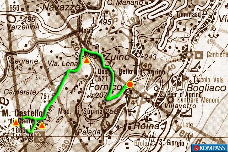
Access: from Bogliaco, a district of Gargnano, on State road S.S. 45 bis, by car to Fornìco; parking.
From the square of Bogliaco, you head south, bearing right near a portico on trail nr. 41. The trail climbs through farmland to the village of Sostaga, at an altitude of 530. You’ll proceed along trail nr. 21. Leaving Villa Lena to your right and the path for Gaino to your left, head straight into the woods. Follow the trail as it gradually climbs beneath the rocks of Monte Castello until you reach a fork in the road at an altitude of 789 meters, with another trail for Gaino, which you’ll take on your return trip (1 hr. 30 min).
Departure: Limone sul Garda (65 m.)
Arrival: Limone sul Garda (65 m.)
Total difference in height (round trip): 2,300 m.
Time: 6 hours
Difficulty: ( E ) Excursionist. Itineraries on trails or tracks, usually marked and sometimes long, with exposed but well-protected sections. These routes require some experience and training.
Period: all year
Map: Kompass n. 071, 096, 101, 102 e 690
Access: along State road S.S. n. 45 bis, from Riva del Garda or from Gargnano, to Limone sul Garda; parking.
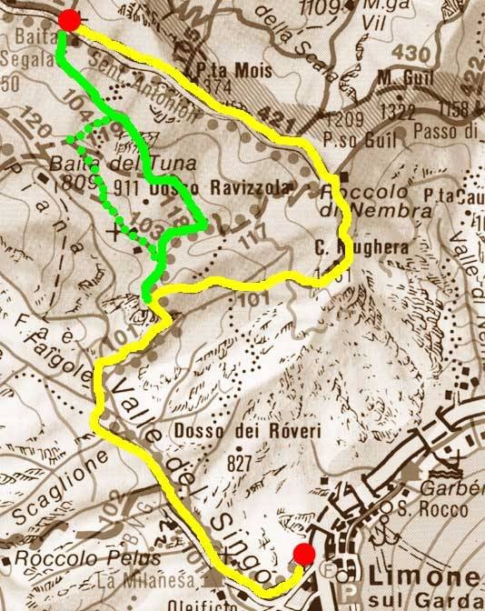
Lake Garda’s alpine and excursionist refuges – From Limone to the ’Bonaventura Segala’ Chalet
The excursion starts out from the bus station at the Turista bar. Take Caldogno and Milanese streets. Once you pass the small bridge of the San Giovanni stream, you walk up the steep cobblestone mule trail that runs through the Valley of Sìngol, following itinerary 101. There are many rivers and streams in the first stretch, and each valley has the characteristic calchére constructions once used to extract lime. Leaving the river behind you, the road becomes steeper. After the three bends of the Murél, you’ll enjoy the beautiful panorama overlooking the valley, closed to the north by the Preàls, Corna Vecchia and Traversole mountains.
You’ll reach a junction (60 min.) with a sign for “Baita Bonaventura Segala”. The trail continues right below the Mughéra peak (1,161 m), where a hill (50 min.) repays the effort with an extraordinary panorama: the village and olive grove of Limone, the hills of Tremosine, the lake all the way to Punta San Vigilio and Sirmione, the morainic hills and, on clearer days, even the Apennines.
Once you reach the CAI-SAT mule trail n. 422, bear left. Passing the remains of military outposts from World War I, you’ll reach the Bocca Guìl (1,210; 20 min.), where you’ll meet up with trail nr. 421 that comes from Leano and leads to Fortini, where the “Segala” chalet is located (1,215 m.; 40 min.). There is a shelter near the chalet for four persons. Beverages are also available. For the return trip to Limone (two more hours), we recommend taking trail nr. 104 that starts out from the chalet and travels downhill until it reaches trails 118, 103 and 101 along the Valley of Sìngol, where it continues uphill for a stretch.
“Bonaventura Segala”
Located in Fortini, in the mountainous hinterland of the town of Limone sul Garda, at an altitude of 1,215 m, it has 4 beds and is open all year round thanks to the A.N.A. Group of Limone sul Garda. Water and wine are always available. For information: Capo-Gruppo A.N.A. Aldo Girardi (tel. 0365.954016).
Departure: Gàrdola (m. 567)
Arrival: Gàrdola (m. 567)
Total difference in height (round trip): 1,140 m.
Time: 5 hours
Difficulty: ( E ) Excursionist. Itineraries on trails or tracks, usually marked and sometimes long, with exposed but well-protected sections. These routes require some experience and training.
Period: all year
Map: Kompass K102
Access: from State road S.S. 45 bis to Tignale along the province road n. 38; Gàrdola; parking.
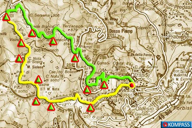
Leave your car in the oil factory parking lot, then take the XXIV Maggio and San Lorenzo roads, crossing the town of Olzano. After passing the “Il camino” restaurant and the “Sunclass bungalows” resort, you’ll reach a panoramic spot over the lake (25 minutes). Turn right on an unpaved road (trail 245 – già 5) that zigzags up the Gumér hill. At the junction, head left and proceed along a fence. You’ll meet up again with the asphalt road for Piemp (15 min). After 200 m. you’ll reach the Bosco fountain and, bearing right, the homes of Bósco de sùra.
At the intersection (10 min), bear left (trail nr. 258) on the trail that borders the Terzanèch fauna area that belongs to the Regional Forestry, and proceed to Fornaci. Passing several barns, proceed to Furnàs de déter and Val dela gèra, where the road ascends slightly with two bends. In the next three intersections, take the road to the left, then the road to the right (15 minutes), and then, as the road ascends, the road to the right.
The road, lined by pine trees, levels out, borders the meadow of Terre Bianche, then ascends, traveling next to the high voltage pylon nr. 291. Bear right and after about 100 meters, you’ll leave the mule trail near the stone marker of A.S.D.F. (make sure the nr. 258 is on the back!). Here you’ll take the trail to the right that climbs up Mount Monte Segàble, crosses the pine grove and after a long stretch, meets up (55 minutes) with the unpaved mule trail coming from Cima Piemp. Turn left onto the trail: after descending along the trail for about 50 meters, you’ll reach Passo d’Ere (1,131), a well-marked crossroads for several inland excursions.
In one direction, the trail leads to Pùria, Scarpapé and Ca di Natone, or Cadria (trail nr. 69-68) or Cima Rest (trail nr. 69), in the other, it crosses the Colomba Pass (1,109 m), via Bocca Paolone (953 m), then proceeds to Valvestino or Costa and Gargnano.
Take trail nr. 259, which descends sharply, leading to a crossroads (15 min.): to the left is the trail that meets up with 258, to the right is a road with barrier that leads to the Visìne and the continuance of 259 which you’ll take to the Luné home (15 min). Turn right, following the signs at the base of the trunk of a huge beech tree. You circle the valley, and when you reach the junction, turn right. You’ll walk up to the small pond in front of the meadow and the home of Gaès (10 minutes), dominated by the peaks of the Visìne.
Turning left and crossing the meadow, after a few hundred meters you’ll reach a bush-lined pasture. In the front is the imposing Mount Monte Denervo, and on the right is a hunting lodge. Follow the descending road, at times paved with cement. You’ll see the meadows and homes of Paül (25 min.). You’ll continue your descent, passing the stream in the Valley of Nota, bordering the meadows and the farm of Pasìne. You’ll reach the source of the river of Cùel (25 min). After a few meters, you’ll find yourself on the Vione road that to the right heads to Passo Fobia, the Nangui malga (or Àngoi) and Bocca Paolone and to the left descends towards the homes of Tignale.
You continue your descent to the junction of Pozze and turn left on trail 251 along the plains of Viù and Val de Presà: Aer is 3 km away. Leaving to your right the connection with trail nr. 265 “B.V.G. – Sentiero Montagnoli” (this could be an interesting alternative that is not easy in the first stretch, for people who want to reach Aer along the “Via dei canài”), you’ll pass the bridges of Val de Presà and Val de Paì. Crossing a chestnut grove, you’ll reach Aer (1 hr. 25 min.). You’ll meet up with the asphalt road and proceed to Gardola, to the parking lot of the point of departure (30 min.).
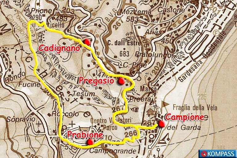
Departure: Campione (74 m)
Arrival: Campione (74 m)
Total difference in height (round trip): 940 m.
Time: 4 hr.
Difficulty: ( E ) = Excursionist. Itineraries on trails or tracks, usually marked and sometimes long, with exposed but well-protected sections. These routes require some experience and training.
Period: all year
Map: Kompass n. 071, 101 e 690
Access: from State road S.S. 45 bis to Campione, between Limone and Gargnano; parking.
Starting out from Campione, along the right banks of the Campione River, is trail nr. 267 of the “Bassa via del Garda” [Lower Garda Route] with a series of steps that lead to a tunnel (15 min: make sure you have a flashlight with you!) and a communication trench between a canal and a deep ravine. Leaving the metal bridge to your right, you proceed along trail nr. 266 for Prabione, which is right up against the rocks. Gradually, the panorama opens on the valley, Pregasio, Cadignano, Sermerio, and the Tignalga and Lavino mountains. The trail turns into a mule trail that travels through a hornbeam woods and exits in Bàit, near a rustic home surrounded by a meadow with chestnut trees (35 minutes).
After 300 meters you’ll see the Campogrande tourist resort. To the right, along an asphalt road, you’ll proceed to the Visitors’ Center of the Alto Garda Park of Brescia, then reach the first homes of the old town center of Prabione (540 m), where you’ll continue on the right along trail nr. 204. As the trail descends, you’ll bear left in the next two forks in the road, then always bear right in the other forks in the road until you reach Puntesèl (30 min), where the trail ascends to Cadignano (30 min.).
You’ll meet up with the province road to Pregasio (478 m), cross the road and, shortly before the San Marco church, take Via Lo, which coincides with trail nr. 267 of the Bassa Via del Garda. Leaving the Villa Selene hotel to your left, you’ll descend along the mule trail to the isolated hay barn surrounded by olive trees (30 minutes). The trail, which is literally dug out of the rock, will take you once again to the San Michele ravine. You’ll cross the metal bridge that you passed during your ascent. Bearing left, and following trail nr. 267 among the nets, you’ll cross the cramped tunnel and reach the piazza of Campione (4 hrs.).
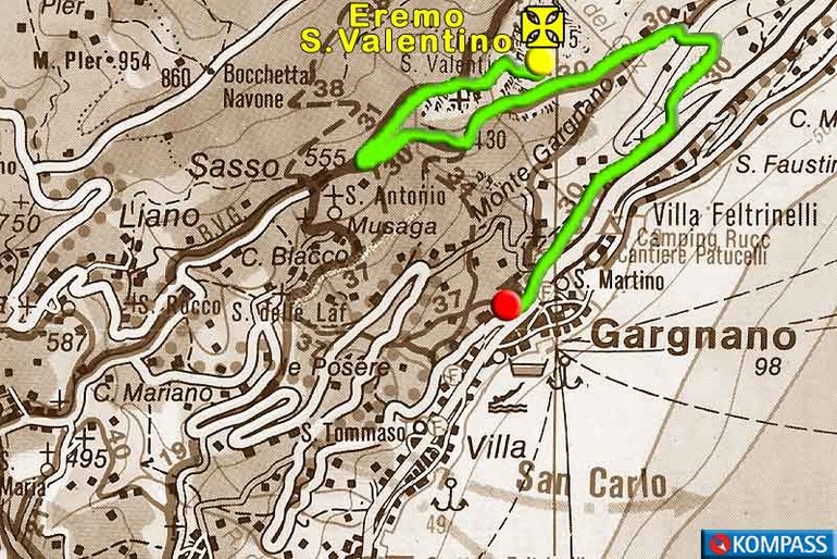
Departure: Sasso (555 m.)
Arrival: Sasso (555 m.
Total difference in height (round trip): 340 m.
Time: 2 hours
Difficulty: T = Tourist. Includes itineraries on roads, mule trails and easy, well-marked trails that have no uncertainties, difficulty or problems with orientation. These routes are also suitable for beginners and first-time mountain hikers.
Period: all year
Map: Kompass n. 071, 101 e 102
Access: from the state road S.S. 45 bis, to Gargnano, take the road for Navazzo and Valvestino; at the intersection, after 7 km, bear right for Sasso; parking.
From the square in Sasso, follow the signs for trail nr. 31 that crosses the town and enters a forest along a mule trail. You’ll pass a stream and walk up to a rocky belvedere (700 m; 35 min.), with a sweeping view of Lake Garda. Shortly after, you’ll leave trail nr. 31 and take the trail to the right that descends to the rocky valley of the Guandalini. You’ll pass a gate that accesses the terrace on which the Saint Valentine hermitage sits (715 m.; 15 min.). The hermitage was built after the plague of 1638. You’ll take the same route back for the return trip (about 1 hour).
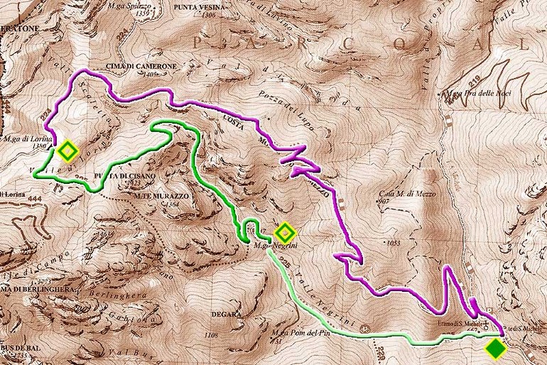
“Sentiero delle tracce”, the Tracks Trail, is a nature trail that winds through the Gardesana Occidentale regional forest, in the community of Tremosine, which is a striking, wild setting along the eastern side of Mount Caplone.
Besides its breathtaking panoramas, the trail offers visitors a chance to observe the tracks left by the local fauna. There are not just tracks left on mud or the snow, but also nests, feathers, droppings, claw marks, stripped bark, the remains of food, burrows, eggshell fragments, exuviae (sloughed skins), spider webs and shells. To hone one’s observational skills, there are several info points along the trail that make the excursion even more interesting.
The recommended route takes you uphill from the Malga Negrini farmstead to Malga Lorina farmstead. The 5 km long trail, which covers a rise of 650 m, is 5 km long and takes about 3 hours to complete. The best time of year for the trail is in spring and fall; there is a risk of ice in winter.
Access with vehicles to San Michele
At the crossroads of Polzone, the village on the provincial road between Vesio di Tremosine and Prabione di Tignale, take the unpaved road for San Michele and the Tremalzo Pass. After 4 km, you will reach a flooded area; you can park near the small bridge that crosses the stream.
The itinerary
As soon as you cross the bridge, turn left at the intersection onto the wide mule track of Val Negrini, which leads to the Malga Negrini farmstead (748 m. – h. 1). Here a granite rock imbedded in the ground marks the spot where the Sentiero delle Tracce, the Tracks Trail, begins. The signage is very accurate, and there are many info panels along the trail that explain the local flora and fauna. The trail zigzags up the mountainside, and the climb gradually becomes steeper along the way. You’ll pass two wide, characteristic recesses (cùen in the local dialect) and the torrent ravine. The trail makes wide curves through the woods and exits onto the meadows of the Malga Lorina farmstead (1,384 m. h 2 – 3.5). In the summer, the farm is inhabited and open for refreshments.
The return to San Michele
From Malga Lorina take the mule track downhill. After you pass the fountain, turn right at the intersection and head downhill to San Michele (h. 2.00 – h. 5.5). The ancient hermitage church, now run by the Franciscan monks, is also worth visiting.
VALVESTINO
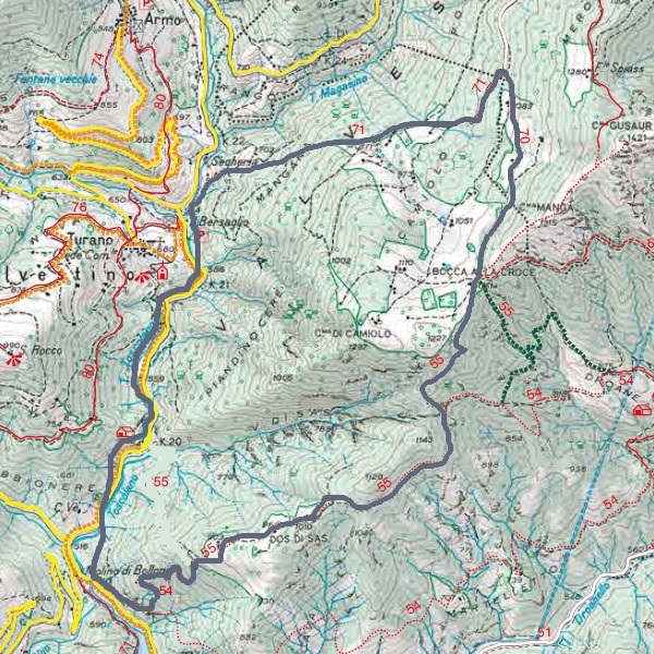
Itinerary: Mulino di Turano (570 m) – Località Bersaglio (590 m) – Bocca alla Croce (1061 m) – Dos di Sas (964 m) – Mulino di Turano (570 m)
Duration: 4,00 h
Allowed: solo Trekking
Difficulty: EE
A circular route that quickly climbs the western slope of Monte Camiolo, where the landscape varies between coniferous forests, broadleaf woods and mown meadows. Breathtaking views of the entire Val Vestino and the artificial lake can be enjoyed.
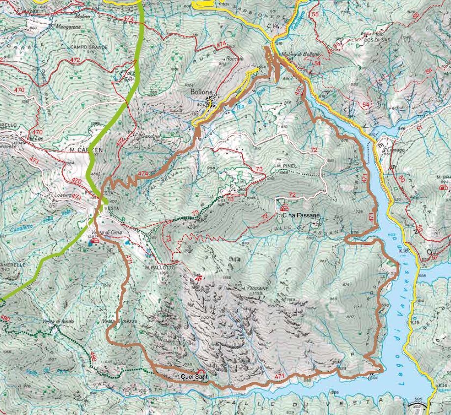
Itinerary: Molino di Bollone (510 m) – Passo di Vesta (1359m) – Vesta di Cima (1287m) – Vesta di Mezzo (1061m) – Cuel Sant (838m) – Molino di Bollone (510 m)
Duration: 6,30 h
Difference in level: 855m
Allowed: trekking only
Difficulty: EE
Ringpath in Val di Vesta, Wilderness area, it’s one of the wildest pre-alpine valleys of Lombardia. The river Vesta, by gathering the waters of the diffrents side tributaries, slides on a tortuous path creating ravines, waterfalls and “il fiordo” of Valvestino Lake. Along the route you will meet three wonderful columns (“cippi”) dated back to 1753, as well as trenches, artillery pitches and fortifications from the First World War.

Itinerary: Cadria (943 m) – Rest (1200 m) – Malga Alvezza (1266 m) – Bivio per Malga Tombea (1796 m) – Monte Caplone (1976 m)
Duration: 6,50 h roundtrip
Difference in level: 1033 m
Allowed: Bike and Trekking
Difficulty: EE
The path starts in Cadria and, passing through a really characteristic beeches wood, you will reach the village Rest, where is located the Etnographic Museum of Valvestino. Going up the street, surrounded by meadows and pastures, it’s possible while admiring barns with thatched roof to reach the Malga Alvezza, and from here to arrive at Malga Tombea. Ascending then the military street of 1915-1918, you will reach the top of Monte Caplone (1976 m a.s.l.), the highest of Valvestino. Here are widespread several rare endemic spieces.
TREKKING BIKE: The path starts in Cadria and, passing through a really characteristic beeches wood, you will reach the village Rest, where is located the Etnographic Museum of Valvestino. Going up the street, surrounded by meadows and pastures, it’s possible while admiring barns with thatched roof to reach the Malga Alvezza, and from here to arrive at Malga Tombea. Ascending then the military street of 1915-1918, you will reach the top of Monte Caplone (1976 m a.s.l.), the highest of Valvestino. Here are widespread several rare endemic spieces.

Itinerary: Molino di Bollone (510m) – S.Vigilio (808m) – Fornel (943m) – Rest (1200m)
Duration: 5,00 h one way
Difference in level: 690m
Allowed: Trekking only
Difficulty: EE
The path, begins in Molino di Bollone and reaches the localities Martelletto, Droane, Fornel, Cassanega, till the Rest upland, offering beautiful views of Valvestino Lake and Droanello Valley.
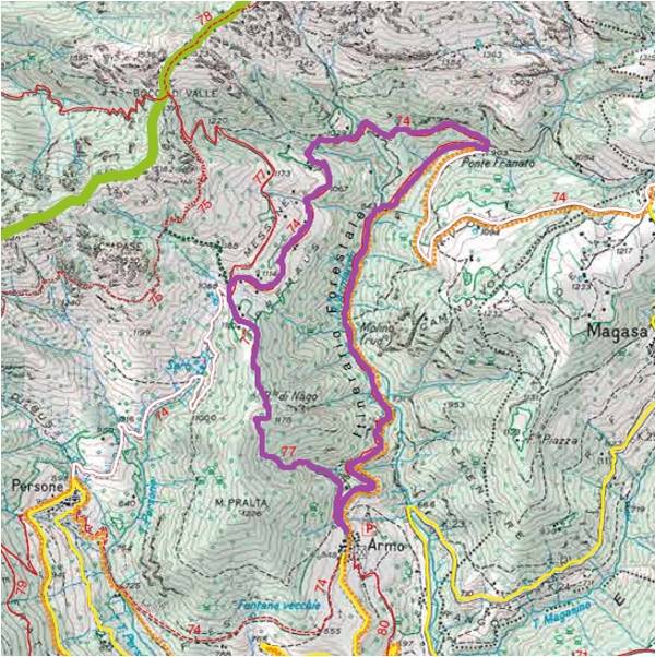
Itinerary: Armo (849 m) – Ponte Franato (903 m) – Messane (1100 m) – Armo (849 m)
Duration: 3,00 h
Difference in level: 400m
Allowed: Trekking only
Difficulty: E
Ring path that from Armo leads to the Armarolo valley, through scots pines woods with monumental specimens. At the second bridge, at “Ponte Franato”, you will meet a crossroads from whence it’s possible to reach Denai or Messane. Once reached the big lawns in Messane the path returns to Armo through a journey which alternate slightly uphill roads between beeches and downhill in the pine forest.
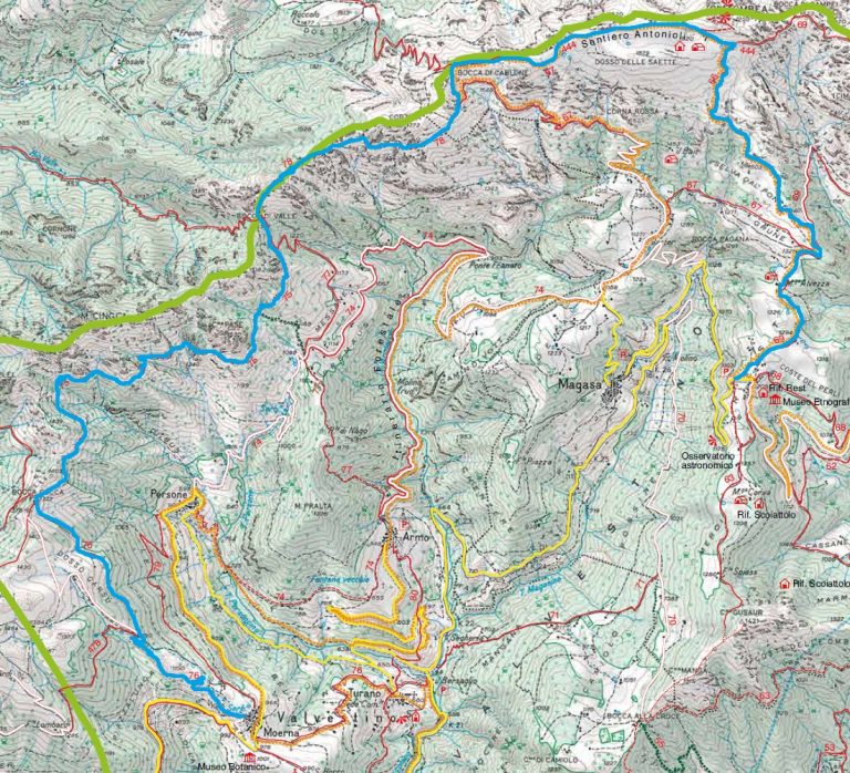
Itinerary: Moerna (992 m) – Bocca Cocca (1327 m) – Bocca di Valle (1392 m) – Bocca di Cablone (1755 m) – Malga Tombea (1825 m) – Cima Rest (1200 m)
Duration: 6,15 h
Difficulty: EE
Difference in level: uphill (Moerna – Malga Tombea) 833mt, downhill (Malga Tombea – Cima Rest) 625mt
Allowed: trekking only
From the parking of Moerna up along muleteers roads that, through beatiful beech woods, rocks and loops, leads to the pastures of Malga Tombea, where it’s possible to admire military bunkers excavated in the rocks, trences and amazing views of Garda and Idro lakes, as well as Val vestino’s woods. From here, along marked paths, it’s possible to descend through pastures towards the Cima plateau.

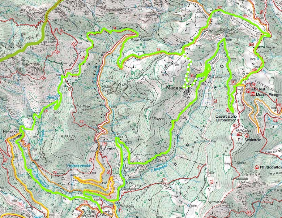
Itinerary: Magasa (965 m) – Denai (1210 m) – Rest (1200 m) – Cadria (943 m) – Magasa (965 m)
Duration: 5,00 h
Difference in level: 450m
Allowed: Bike and trekking
Difficulty: E
Ring path that starts from Magasa and climbs up on the ancient way which connected the village to the pastures of Denai and Vott. Passing through the pastures of Denai you will reach, by crossing Malga Alvezza, the little church of Cima Rest. From here, you can choose to continue forward till Cadria and back, or going direct back to Magasa.
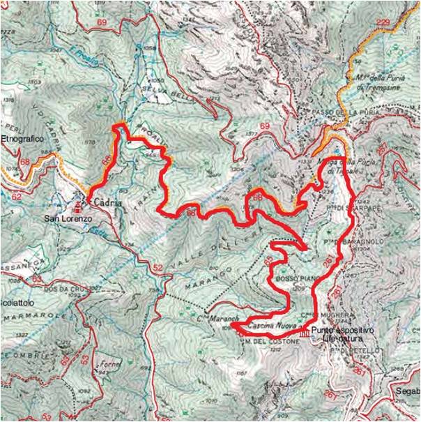
Itinerary: Cadria (943 m) – Passo della Puria (1374 m)- Cascina Nuova(1194 m) – Cadria (943 m)
Duration: 4,00 h Difference in level: 430m
Allowed: bike and trekking
Difficulty: E
Ring path that starts in Cadria that, by diving into the woods of Valvestino alllows the visitor to discover the fauna of Parco Alto Garda Bresciano. By walking next to the clearings and the edge of the wood can happen to sight a roe, a stainbock,a deer and a lot of other animals, inasmuch as in Valvestino it’s ascertained the presence of over 150 species.
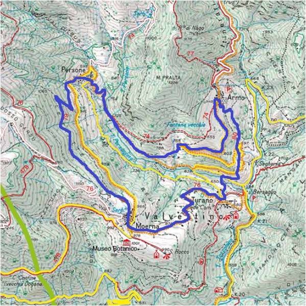
Itinerary: Turano (676 m) – Armo (849 m) – Persone (900 m) – Moerna (992 m) – Turano (676 m)
Duration: 3,30 h
Difference in level: 360 m
Allowed: Trekking only
Difficulty: E
Ring path that starts from the little square of Madonna Pellegrina in Turano, climbs up to Armo, reaches Persone and then going up till 1100 m in the woods leads back to Turano passing through Moerna accross the ancient streets.
Itinerary: Turano (676 m) – Armo (849 m) – Messane (1,100 m)– Persone (900 m) – Moerna (992 m) – Turano (676 m)
Duration: 3,30 h
Allowed: Bike
Difficulty: E
A circular route that starts at the little square of the Madonna Pellegrina in Turano, climbs up to Armo, reaches Persone and finally, ascending through the woods to an altitude of 1100 m, leads again to Turano via Moerna along the old roads.
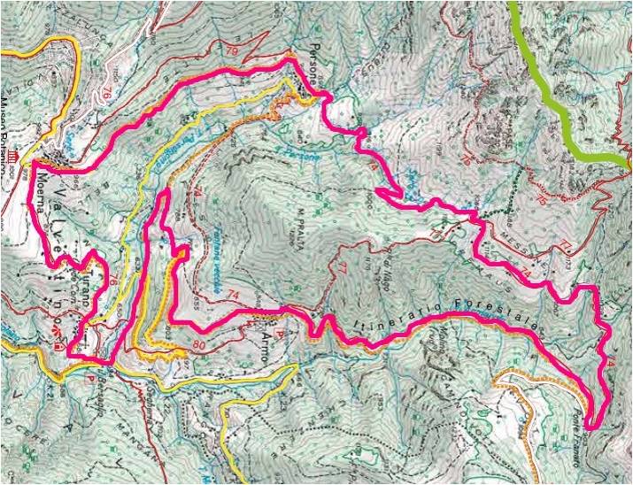
Itinerary: Persone (900 m) – Messane (1.100 m) – Ponte franato (903 m) – Denai (1.210 m) – Rest (1.200 m) – Magasa (965 m) – Turano (676 m) – Persone (900 m)
Duration: 5,00 h
Allowed: Bike
Difficulty: E
A circular route that starts at the little square of the Madonna Pellegrina in Turano, climbs up to Armo, reaches Persone and finally, ascending through the woods to an altitude of 1100 m, leads again to Turano via Moerna along the old roads.